Driving Home
- Michael Lee Jackson
- Sep 3, 2019
- 19 min read

Updated: Jan 11, 2020
Over the last few years, I’ve spent a lot of time driving home, a condition exacerbated by the fact that I live in Los Angeles and somewhat regularly drive back to Buffalo where I have family, old friends and business. My holiday commutes are epic. Some people think of the idea of regularly driving across country as a nightmare, but for me it’s soul food. Those trips are massive opportunities to explore, slow down, divert, check out rural roads I’ve never driven, many of them not even paved, meet and talk to people, take photographs, adapt, learn, live and then hopefully share.
The photographs in this collection are almost entirely from those drives over the last couple years. This is contemporary America as I’ve recently seen it on back roads avoiding highways as much as possible. People tend to think of the word “contemporary” as modern, but contemporary also means now, as in contemporaneous, which isn’t necessarily modern. As much as some of these photographs look like they could be from long ago, they’re not. There was a time when these towns, old homes and churches were modern and the buildings new, but the faded cracked paint tells us that particular prosperity was long in the past. And much as the desolate scenery tells a story of a tough life in rural America, there is also an abundance of beauty and smaller towns that are prosperous. Most people in the United States live clustered in big cities, but most of this country is rural. In rural places people live vastly different lives than they do in cities, and these divergent existences occur contemporaneously. I firmly believe that any worthwhile attempt to understand this country must include the rural and the urban.
It is my hope that by sharing pictures of these old towns, rural wreckage and some of the great expanses of farms, mountains deserts and other quirky things I’ve seen along the way, that some viewers might be reminded that the bubbles most of us occupy are also echo chambers and there are many people out there with vastly different lives.
At the exhibition each image has a QR code that leads to stories about the image and related images. Those pages aren't directly accessible on this site so I've collected those stories and images, edited a bit, assembled them into this blog post and added some more stories and background photos. Acknowledgements and thanks for those who made this possible are at the end of this post. Enjoy!
Church and Storm

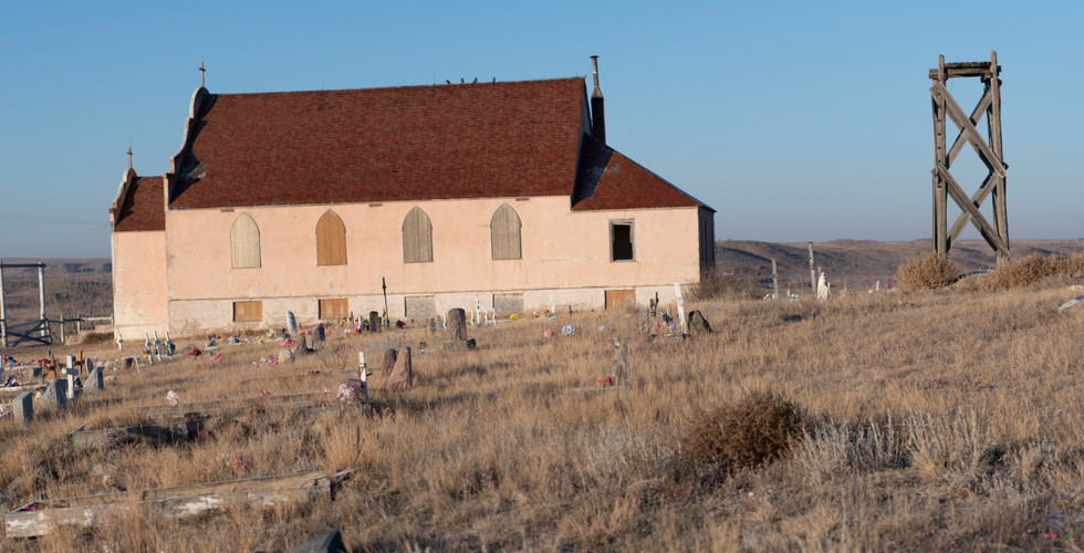
It was July 31, 2016 and I was driving west to Los Angeles from Buffalo, via northern Minnesota where I picked up my buddy, Chris LaLonde at his house. It was an entire day out of the way, but hey, I’d never been up there and Chris had offered to drive the rest of the way back with me. The afternoon I took this photograph we’d cautiously been watching the sky in front of us as it started to look more and more ominous. Just before taking this picture I’d received a weather alert on my phone advising me urgently to take shelter because of tornados in the area, which by then was obvious because of the mammatus clouds. At that moment I saw this church, then known as the New Bethel Center church. We pulled over and just before the skies unleashed the obviously pending deluge I was able to take this photograph, and dash back to the car.
I think it was Chris’s turn at the wheel at that time, and I was trying to look on my phone at the radar using several apps so we could do our best to avoid the worst of it. It was then that T-Mobile sent me a notice advising that I’d used all my free roaming. There was a link in the text to buy more bandwidth which I couldn’t use because I didn’t have adequate signal.
When we arrived in whatever town we made it to that night, I called T-Mobile and the conversation went something like this:
TM: How may we help you, sir?
MJ: I have questions. Do I have an unlimited plan?
TM: Yes, sir.
MJ: And is it nationwide?
TM: Yes, sir.
MJ: With no roaming charges in the continental United States?
TM: Correct, sir.
MJ: You have just told me three lies…
There was no satisfaction to be had, of course, though they did extend me some blocks of ‘free’ roaming time.
When I first showed this photograph at the Los Angeles Art Show, many people asked if the sky was real. It was and is. It’s a bit more dramatic in black and white, of course. Another man asked me what this image says about my position on Christianity, to which I replied, what does asking me that say about yours?
Sunflower Audience

It’s difficult to remember where I took photos absent GPS data or good notes. Sometimes I have both, and sometimes I have neither. While I remember pulling over and walking around in this field quite vividly, neither of the cameras I was traveling with have GPS, and I failed to make any notes of use. I can tell from the pictures that precede and follow it that it was on a small road somewhere in between Witten and Winner, South Dakota.
I thought it fitting to drive home for a show called “Driving Home,” and I took this picture just a few weeks before the launch of this exhibit. I already had the exhibit set on to-scale walls I constructed in Photoshop, but I didn’t get the placement of the outlets on the west wall of the Lipsey Room, and the adjustment created space for one more image, this one. I was delighted to be able to include this image as it provides an optimistic contrast to the gloom and doom to the right and left of it in the exhibit.
Several days prior, I was in Jackson Wyoming for two nights, and finally was able to photograph some grizzly bears thanks to my friend, Dwight Vassell, who lives there part of the year working as a professional photographer and tour guide. My visit luckily coincided with him having a day off, and when I asked him what he felt like doing he said “Let’s go out and shoot!” I thought that quite generous considering that’s what he does every day for work. We had a blast exploring a dirt road outside Jackson that he’d never driven and with spectacular views of the Tetons off to the west.
The next day, I drove up through Yellowstone and took the Beartooth Scenic Highway which leads from Cook City and the North East entrance to Yellowstone over to Red Lodge, Montana. I was looking for a way to avoid having to go all the way to Billings before heading east and noticed a small road that went east from Red Lodge. MT 308 heads due east from there towards Bearcreek, an old mining town, and I eventually made my way south east to the Bighorn basin.
It was there, after passing Lovell, Wyoming that I came upon the old Mason-Lovell ranch, behind which was a very ominous sky, clearly capable of generating tornados. I snapped a few pictures and hit the road hoping to stay ahead of the storm. I was lucky enough to stay slightly south of the storm, but received notices about tornados and golf-ball-sized-hail as I made my way towards and through the windy mountain roads of Bighorn National Forest with the occasional emergency alters coming through on A.M. radio. Those hail storms are no joke. I’ve seen the destroyed homes and vehicles on the Pine Ridge reservation to the south east and it looks like there was war. One informational sign at the ranch explained that in order to work at this ranch workers were asked if they smoked and wore suspenders. If they answered yes to the first question, Lovell didn’t want them because he figured they’d be spending all their time rolling cigarettes. If they answered no to the second question, they also didn’t get the job because Lovell figured such workers would be spending too much time pulling up their pants.
I made it out of the mountains to Ranchester, Wyoming as it was getting dark, the storm still visibly looming not far to the north. The check- in clerk at my roadside motel told me that this weather was unusual for Ranchester, WY, and further that it's no longer enough to have done good and expect that god will protect you. "It's different now," she said. The bartender at the saloon didn't seem worried about the warnings, though she too opined that this weather has gotten weird. The bartender also told me city folk just don’t understand what it’s like to live out in the country. For example, she said one of her nieces was horrified that she pays her kids a dollar for every rabbit they shoot. She said to her niece “Are you crazy, those little fluffy monsters undermine the foundation of this house and ruin the sidewalk over and over and they…” she paused and I added “fuck like rabbits?” “Yes!” she proclaimed, “Exactly!”
The next day I drove on through the nearby old west town of Sheridan where I made a note to return and photograph it more. And made my way east on US 14, which is such a stunning drive in Wyoming. I came upon Recluse road and turned the car around. If there was a town called Recluse I had to check it out. It was only about ten miles out of the way. A woman named Connie Oedekoven (married name) came out to say hi when she saw me taking pictures of the old general store, gas station and post office. Her husband’s family has been there since the 1920’s. She used to run the general store during an oil boom decades ago, and she worked on cars, trucks, was post master for a while and in her words “I did it all…” She moved there in the 1950’s after a stint at art school in Boston. Her brother, who she says is much smarter than she, got a degree from MIT and went on to be involved with developing the scanners we use in supermarkets and missile guidance systems. Connie’s husband’s grandfather built the post office/general store behind her, and the log cabin her husband was born in still sits across the street behind the newer post office. A few years back after a hay truck crashed into the building he put in that steel guard rail around the street facing side of the general store/old post office building. Now that building is more of a repository of town history, with pictures of the place from over the years. It’s not open to the public, but Connie is super friendly will happily show it to strangers who inquire.
In between Sundance, Wyoming and Deadwood, South Dakota, we came upon the Ranch A property about five miles up Sandy Creek Road. There was a gorgeous green meadow in the canyon with a stream of crystal clear water which Shadow enjoyed for an hour or so while we had a break before marching on to Deadwood. Deadwood is a fabulously well preserved old west mining town. It was a little crowded for me so I barely stopped except to go see the graves of Calamity Jane and Wild Bill, who are next to one another at the Mount Moriah cemetery, up a steep hill outside of town. Calamity Jane’s headstone appears original, but Wild Bill’s was a big disappointment as it has been been replaced with a modern bronze statue. As I was coming down from seeing the headstones, I stumbled on a rock and did a fairly full body plant on the rocky ground beneath me. I had a split second to decide whether to save the Nikon and Leica both strapped around me, or myself. Of course I protected the cameras. And nearly two weeks later, the wounds on my knees are healing up nicely. There’s a lot of history (and parts of my knees) in that cemetery and I intend to get back there one day.
Here is a slide show with some other pictures from the August 2019 road trip. *(see explanatory note on why I can't have a grid gallery here at the end)


Dirt Road & Rain

“Damn any man who sympathizes with Indians! ... I have come to kill Indians, and believe it is right and honorable to use any means under God's heaven to kill Indians. ... Kill and scalp all, big and little...”
-United States Colonel John Chivington
This photograph is from July 15, 2017, and was taken on a dirt road in eastern Colorado not far from the site of the Sand Creek Massacre.
On November 29, 1864 U.S. Colonel John Chivington and a cavalry of 700 or so volunteer troops attacked a group of Cheyenne and Arapaho native Americans who were living along Sand Creek in south eastern Colorado, many of whom were killed in their tipis or from the back as they fled. Then Colorado territorial governor John Evans had promised he would protect Colorado citizens from “hostile Indians” and urged citizens to “pursue, kill and destroy them.” It is estimated that up to 500 Cheyenne and Arapaho were massacred that day in 1864, two thirds were women and children.
The Treaty of Fort Laramie in 1851 between seven native American nations, including the Cheyenne and Arapaho among others, recognized the vast lands from the central Rocky Mountains north in to Wyoming and east in to Kansas and Nebraska were home to the Cheyenne and the Arapaho. Then gold was discovered in the Rocky Mountains in 1858 which led to a massive influx of immigrants over the Cheyenne and Arapaho lands, competing for resources and land.
In 1861 the Treaty of Fort Wise was signed at which the signatory Native American nations ceded back to the United States most of the territory they were granted in the Treaty of Fort Laramie ten years earlier. Some bands of Cheyenne and other nations were angry about the treaty which left them with 1/13 of their prior lands, said those who signed were bribed and did so without proper authority, and disavowed the treaty. Those dissenting continued to hunt on their prior lands and conflicts and tensions rose between them and the influx of white people from the east.
In July 1864 governor John Evans invited “friendly Indians” to Fort Lyon in the Eastern Plains for their safety. Cheyenne chief Black Kettle and Arapaho chief Niwot and their followers were among them, until being asked by the authorities to relocate to Big Sandy Creek for their safety. The men who went to Sandy Creek were mostly too old to hunt and the rest of the Cheyenne and Arapaho who moved there were women and children. Chief Black Kettle flew an United States flag with a white flag underneath it over his lodge as advised by the Fort Lyon commander.
Not much later, and with the U.S. flag still flying over Black Kettle’s lodge, Colonel Chivington assembled his men to go to the encampment and gave the attack order, an order followed by all other than a few companies of troops. After the indignity of the attack, the murdered Cheyenne and Arapaho bodies were severely mutilated by the troops, and body parts were taken as souvenirs.
Though there were United States investigations of Chivington’s massacre and both he and the events were widely condemned, no one was punished or formally charged with any crime.

Choose Your View
This is the first, and the prototype, for a series tentatively called "Windows." I collect old windows and when I can, I get the story on where they are from. I think about the lives that have been lived behind them and the sights seen through them. I also have observed a lot of rooms that could benefit from a window and an interchangeable view where there isn't or can't be one. The images in this piece are interchangeable, so if the current view east of Oatman, Arizon doesn't stir one's soul, it could be a beach or a farm or snowy mountains. The images slide in and out from the back. Each piece is unique. This window was from a home in Freedom, NY.

The image that is currently in the Window was taken last November on my way east for Thanksgiving dinner. I'd just passed through Oatman, Arizona en route to the Grand Canyon and came upon this otherworldly view.
Abandoned Farm House

A spectacular day it was on January 12, 2019 when I drove through Short Creek, North Dakota. We were making our way west along the Canadian border as much as possible on farm roads. The goal was to photograph and experience the winter desolation up there. It was beautiful and harsh. Inside this house, which I knew I should not have gone in to for safety reasons, among other things, there was a bed on the second floor, well the metal remains of the bed that was there. On it was a dead bird, which I believe to have been a hawk. There is a picture of it below as well as a few others from that magical, but frigid day.
I'm fascinated by these shells of previous lives and I always wonder what happened in those homes, the dreams, the heartbreak, the hard work and why they're finally left. I explored one abandoned farm house in Montana a couple years ago and found bank records going back to the 40's, clothes still hanging, median on a counter, the old washing machine and furniture. There are also a few pictures of that home in the slide show below.


Country Road & Low Clouds

This photograph was taken August 5, 2018 near Elmore, Minnesota. I’d been chasing that cloud for a while and looking for interesting foreground, and this road, U.S. 169 sufficed, as did a train just slightly to the west. That same train is in the image above as well. Elmore was further south along that road from where I took this. There are a few other pictures from Elmore and around there in the slide show below.


Barn & Grass Driveway

It was August 5, 2018, and I’d been driving through some beautiful rolling hills in Minnesota when I came upon this barn somewhere near Rushford. Aside from the lush green, I love the geometry and textures in the barn and side building contrasted with the obviously newer dumpster.
Abandoned Church & Snow

As part of an epic winter drive along the Canadian border and then south in Montana to Yellowstone and points south in January 2019, my buddy Steve Tepper and I did our best to avoid interstates and managed to take rural paved and unpaved farm roads through most of Utah until we finally caved, got on the U.S. 15 near the Nevada border and from there blasted all the way to LA.
This church was in Ovid, Idaho off the U.S. 89, which is a spectacular drive for the most part. I was in snow up to my waist taking this image. On August 28 I showed the exhibit to Penelope Creeley, and she said this image reminded her of one of Robert Creeley's poems he'd written during their time in Kuala Lumpur which she recalled verbatim:
Sufi Sam Christian
Lift me into heaven
slowly 'cause my back's
sore and my mind's too
thoughtful, and I'm not
even sure I want to go
The clouds that day were stunning we were, except for the time we spent later that day circumnavigating Salt Lake City on farm roads in the mountains during a blizzard. We ended up in Provo Utah that day, desperate for hotel rooms, a meal and a drink. The drinks were not to be had at any of the restaurants we checked out in Provo, though the food was passable. The first hotel we looked at seemed to be hosting a student zombie apocalypse. Tepper went in to check a room at the second hotel we looked at, and when he touched the bed, it collapsed. That’s kind of how the night went with looking for restaurants and such. Eventually, we found a fabulous hotel and Tepper managed to parlay his erstwhile negotiating skills into really nice suites for both of us. Shadow had his own bed in mine. It’s little victories like that that contribute to survival on the road, especially after a long white-knuckled driving day.
Below are some pictures from the road that day.


Lost Springs, Wyoming

I happened upon Lost Springs, Wyoming on my way west in the late summer of 2018 after visiting the Pine Ridge reservation to the east in South Dakota. I'd never heard of it. The sign on the street said the population was 1, but I understand there are now 4 residents. It's the smallest incorporated town in Wyoming and has been since 1960. It was founded in the late 1800's as homesteaders came through, and with the railroad going right by it, Lost Springs was the location for loading up shipments from a nearby coal mine that closed in 1930. At it's peak, Lost Springs had two hundred residents, a number which steadily declined after the mine closed. The bar is reportedly still open for major holidays and during hunting season.
Train Tracks and Hay Bales

This image was taken July 13, 2018 in Nebraska somewhere east of Dix on U.S. 30. I saw so much beautiful scenery that day along the way, explored an abandoned old western town in Colorado, took farm roads in Iowa through rolling hills and farms, and I talked with strangers in small town diners and general stores. Below are a few pictures around this same spot, the beautifully maintained town of Livingstone, Nebraska where the people I met were very excited about the new breakfast wrap place in town. I tried it, and it was great. The older buildings and cars included below are from Lodgepole, Nebraska, and the rolling farm hills were off a dirt farm road in Iowa.
More from around here in the slide show below.


Sunken Dodge and Silo

This photograph was taken near Madoc Montana, on January 13, 2019. From route 5 as we headed west just south of the Canadian border I could see the old silo, which was my cue to pull off the road and have a look. While walking around the silo, I saw this Dodge (incorrectly labeled as an Oldsmobile at the show) and that became the most interesting thing to me there. The tires sinking into the ground are one of the measures of time gone by since it was left in this probably final resting place.
Below are a few more images from the property where the Oldsmobile was, as well as a couple pictures from Westby, Montana and the abandoned Fortuna, North Dakota air force radar station and town of Fortuna, all to the east.
See more from around this place in the slide show below.


Pink Church

The Pink Church, otherwise known as the Sacred Heart Catholic Church is a beautiful old mission style church, unusual that far north, and Native American cemetery are located east of Harlem, Montana on U.S. Highway 2 on the Fort Belknap Indian Reservation.
I’ve visited this church a few times and it’s always quite moving. A few more pictures of the church and cemetery are in the slide show below.


Mountains, Meadows & Wildflowers

Narnia has nothing on the terrain around Crested Butte, Colorado. Dirt roads head farther into the mountains in multiple directions and it’s an endlessly beautiful playground. There are old mines, gorgeous streams, and wildflowers. It was difficult to choose a picture for this exhibit from Crested Butte because I love it there so much. This picture was taken July 8, 2018. The approach to Crested Butte was stunning as well as I came in from the west and took CO 12 over the pass and into town. It’s mostly a dirt road, and a truly stunning drive through aspen groves. I came upon a herd of goats near the top, and were it not pouring, I’d have gotten out of the car and photographed them.
This journey home started with a drive north from LA to Humboldt County, where I photographed a marijuana farm, and then headed east through the Donner Pass on the loneliest road in America, so it's billed, U.S. 50, which in Nevada is truly spectacular going through old mining towns, abandoned towns, and just lots of nothing. It was sublime.
Lots of pics in the slides below below.


Monument Valley

Between the westerns I grew up on and a few childhood family trips that took me through Monument Valley, this special place has always made my heart pound. It's located on the Arizona and Utah border, and the tallest of these red sandstone buttes is a thousand feet high. Director John Ford filmed here for some of his best known films, as have many others.
The iconic views we've all seen before are so much more encompassing and awe inspiring in person. The picture above was one of those rare times when on the road that I actually had time and decided to wait for the light.
It's more dusty in there than you can imagine, and pretty bumpy too, but it's worth getting in there, preferably with a 4x4 and exploring it on your own. You do need permission to go on many of the roads as it's on a Navajo reservation, but the signage is adequate in that regard.
A few more pictures from this area are below.


Empty Heart & House

The best I can discern from pictures preceding and following this one is that It's a farm house I stumbled upon somewhere between Austin, Nevada and Scipio, Utah on my way west to Crested Butte, Colorado. I love that someone took the time to create this graffiti art inside the abandoned home where only the most curious would see it. And as for the story behind the message, I'd love to know. Below is another image of this house.

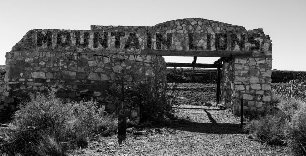
Two Guns Garage

This service station at Two Guns, Arizona burned in 1971. But the recent known history before that is pretty dark as well. By recent, I mean since the 1800s. The earliest artifacts there date from 1050 AD.
In 1878 at Two Guns, Navajos exacted revenge on Apache warriors for a prior attack who were hiding in a cave. The Navajo set fires to smoke them out. The Apaches that tried to escape were shot, and the 42 Apaches that stayed in the caves died from the smoke. The cave was dubbed the Death Cave sometime later. In 1879, Billy the Kid and his gang hid out nearby on the west rim of Canyon Diablo across from Two Guns. Not much later as the railroad was coming through, this area was known as a pretty lawless place and was the site of a famous train robbery in 1889.
Among the first settlers there was Ed Randolph, who built a store right by the death cave. In 1922, Earle and Louise Cundiff purchased 320 acres from Randolf for $1,000.00. Harry E. Miller, who called himself “Chief Crazy Thunder,” later leased land from the Cundiffs and built a zoo along the canyon with mountain lions, gila monsters, and others. Miller also opened a store, cleaned out the death cave and sold skulls as souveniers. He also sold tours of the cave where he’d installed lights and other attractions.
In 1926 the road passing Two Guns became part of Route 66. Later that year Miller murdered Earle Cundiff over a lease dispute, though he was acquitted. Later Miller’s store burned and he suffered terrible wounds from mountain lion and gila monster attacks. He left the state in 1930.
Other businesses have tried there since, including a KOA camp ground, but all that remains are unlabled skeletons of prior businesses there, the shells of old buildings, ruins and graffiti. There is not a single sign there to tell you that any of the above happened.
The pictures below are from Two Guns.


Smallest House

In Randolf Utah, South of Bear Lake and the Abandoned Church and Snow photograph, on January 17 we happened upon the Smallest House In Rich County off UT 16. The drive there was exquisite, as was the drive south towards Provo and beyond. Some more pictures from near Randolf and south are below. The picture below of the mountains and lake was as approached the pass to Provo. Not shortly before that we had to detour because an avalanche had left forty feet of snow on the road that day.
And that's the show. The below photo is the first model I did of how I thought I'd lay the show out. I learned when we went to hang the show that I had more room than anticipated on the west wall, so we added the sunflowers in the middle. Beneath that are the JPGS of the to-scale layout I did of the room in Photoshop. Even with those I misjudged the west wall, and it turned out I had room for the sunflowers, about which I was delighted. Also below is a video of the exhibit just before the friends and family reception opened on 8/30.


Here is an iPhone video walk through of the exhibit.
Acknowledgements and thanks
This show would not have happened if not for the invitation of Kristie Pottle who is Director of Programming and Special Events for the Hotel Henry. The theme of the show was Kristie's idea as were the QR codes, and she helped me choose the specific images as well. The hotel did a fabulous job promoting the show and in hosting it with a generous opening reception. Thanks also to Bruce Jackson, my father and inspiration to do this in the first place. Thanks to Tom Irwin for his advice and help along the way as well. Thanks to Chris Lalonde for his help on many of these journeys and in proofreading the stories accompanying these images. Special thanks to Barry Covert, Esq., and Lipsitz Green Scime Cambria LLP for their generous support which also made this possible. And finally special thanks to Buffalo Big Print for doing a fabulous, fast and enthusiastic job printing and mounting everything for the show, and to Chris Kameck, who expertly hanged each image at the exhibition. As with many things, it takes a village.
For any questions about prints or otherwise, please contact me here.
______________________________________
*The blog/photo functionality on Wix.com which I use for this site is prehistoric. I don't have the ability to drop in any galleries which are clickable or photo descriptions unless I just post each image separately, and this is after going up to tier 3 on their customer support today. So we're stuck with manual slide shows for now, the best worst option. They say they're working on that functionality, so when and if they improve it, I'll update this post.


Comments