Road Trip Chronicles #47 Los Angeles to Victoria, British Columbia
- Michael Lee Jackson
- Jun 3, 2018
- 16 min read

Actually this is the first Road Trip Chronicle I’ve written titled as such, and #47 is probably an underestimate. It all starts out innocently enough. I get home from a trip somewhere and I need to keep it going somehow. In this case, I was recently back from a fabulous trip to Thailand, and as soon as I dusted off, I thought I'd drive up to British Columbia, have a drink or two with my dear friends, Mike and Melissa Wilson, and then head back via a different route.
A Journey Begins
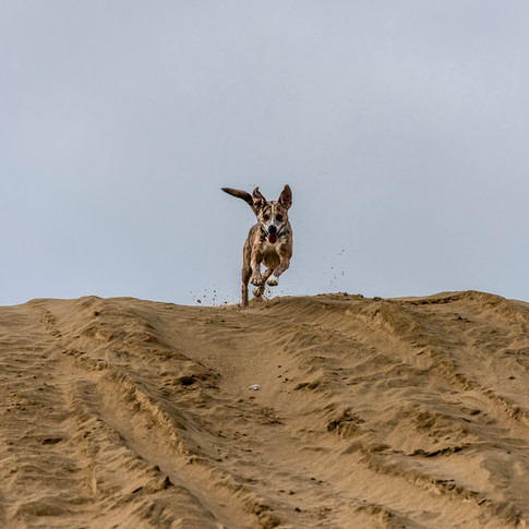
So on April 21, 2018 off I went with trusty co-pilot and recent friend, Steve Tepper, a recovering lawyer, photographer, avid adventurer, fan of great rock and roll and biker, and of course no trip would be complete with Shadow, the adventure dog riding along.
The plan was to go up inland, hit Crater Lake, the ghost town of Shaniko, Oregon, and then head west along the Columbia River and then northwest to the Olympic Peninsula. The plan for the return trip was to hug the coast of Washington, Oregon and northern California as much as possible, and then get back to the 5 to get back to LA. That’s more or less what we ended up doing along with a healthy dose of diversions and plan changes along the way..
I learned over and over on this trip about the value of unscheduled diversions. No matter how well you schedule and plan routes, if you’re married to an agenda, there’s a lot you’ll miss on a road trip. For me, schedules and routes on road trips are like recipes. They’re recommendations. You don’t know what you’re going to happen upon along the way. And it’s worth being flexible to be in the moment and see what you might find. It’s all about the unscheduled stops. The stuff you didn’t know you’d see. The beautiful and the weird. There’s no shortage of either in the pacific northwest.
I Didn't Think Things Would Get Interesting So Quickly.
About two hours into the drive, we were coming down the Tejon Pass, just south of Gorman, CA on the Grapevine (Interstate 5) and the mountains were alight with gorgeous poppies. Wildflowers in southern California were underwhelming this year as we’d had so little rainfall, so I wasn’t expecting that at all. Last year I’d reached out to the corporate office at Fort Tejon to ask about getting on the land to shoot the wildflowers, but there were no options available that appealed to me.
I saw an exit for Ft. Tejon State Historic Park right by where the flowers were. We explored a little bit and found Digier road, which quickly turns into a dirt road, and which snakes up and around a canyon in those mountains across from where we'd seen the flowers. It all appeared to be fenced, posted and private property, but as we came back down, there was the elusive view of those mountains I’d been chasing for years, and in perfect light. A picture is below.

Wildflowers along the 5 on Tejon Ranch
Onward. Once we were in the central valley heading north, devoid of temptations until northern California, we made very good time. The windows were tightly sealed and I changed the air circulation to internal only as we passed what we call “Cowshawitz” which is an enormous swath of factory cattle ranches with an odor that will pucker the most resolute.
The first day we made it to somewhere just south of Klamath Falls, Oregon, with a several hour diversion exploring up and around Mount Shasta, California. All in, it was about a 750/800 mile day. We didn’t plan for Shasta, and couldn’t really find the right place to shoot from as we raced the sun which was rapidly falling from the sky. Sometimes chasing light works out, but in my experience, there is an element of luck and you just have to be out there somewhere with your eyes open. I’d remembered a view point of Shasta from the west which I’d seen a year earlier when I was going south, but couldn’t quite remember where it was. The thing with mountains, as obvious as it sounds, is that you have to be quite a way back to actually get a decent picture of the entire mountain, if that’s the goal. So, with that goal in mind, driving towards, rather than away, from Mount Shasta perhaps wasn’t the smartest thing to do as the sun was going down. We did stop at one spot as the sun was disappearing and I took the below picture. After the good light was gone and a bit further up the 97, there was the “View Point” sign and the place I’d previously shot from on the left. Steve and I simultaneously saluted that sign with a middle finger in the then faded light.

Mt. Shasta
Getting to Crater Lake
From the 5 north we trudged along up the 97 in Oregon towards Crater lake, where the roads had just been re-opened after a big spring snowfall. Half the fun of going to Crater Lake from the south is the drive starting with the gorgeous marshlands along Upper Klamath Lake, just past Klamath Falls. This is where the drive starts to get extraordinarily beautiful. To the north, Upper Klamath Lake becomes Agency Lake and to the west across the lake are the Cascade Mountains of southern Oregon in the Sky Lakes Wildnerness, and standing tall was the still snow capped Mount McLoughlin, a volcano that hasn’t had much action for 20,000 to 30,000 years. I must go explore around there next time I point the car in that direction.
While passing Upper Klamath Lake, I noticed a beautiful old and decrepit stone building (at approximately 42°26'50.13"N x 121°52'24.48"W) just off the road. We took a dusty dirt road to it. It appears to be private property, so be careful if you check it out. We didn’t see anyone in there. I took a few pictures of it and noticed a hole in the side of the wall big enough to crouch through, so I went in. As I entered, I must have startled a sleeping snowy owl which took off right at me and flew over my head and out through the missing roof. I’d always wanted to see a snowy owl, and finally did. Epic. Perhaps next time I see one I'll be able to photograph the beautiful creature. We hung out for a bit there before continuing towards Crater Lake on the 97.


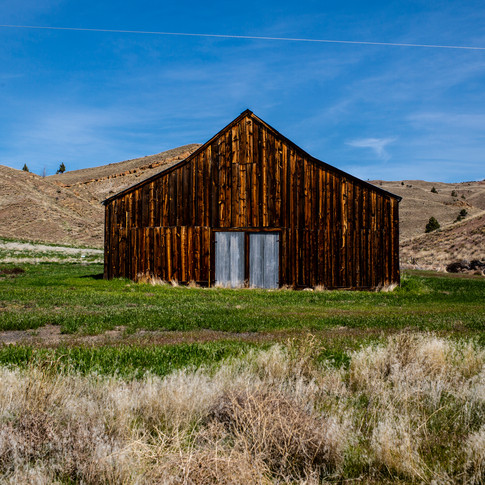
A few miles further up the 97, we branched off to the north west on 66, we spotted this huge old barn that had been taken over by birds off the side of the road, so we stopped for a few pictures. (Barn is at approximately 42°39'3.56"N x 121°57'27.57"W). The house and tree in the pics immediately below was to the left of the barn.


Our next unscheduled stop en route to Crater Lake was the small community of Ft. Klamoth, which has a few beautiful abandoned buildings by the corner of Weed Road and the 62.


Other than stopping to let shadow have a swim in a river and take a few pictures along the way the next stop was Crater Lake, where there was still quite a bit of snow. And this was only half way through day 2. Crater lake is one of those places you can see pictures of but never really appreciate the beauty until you're standing in front of it. It's a vast caldera at 5x6 miles across, so vast that my 16mm lens can't get the entire lake in one image. It's also the deepest lake in the country at over 1900 feet deep. It was formed approximately 7,700 years ago by the collapse of the volcano, Mount Mazama. The water in crater lake is regarded as some of the cleanest freshwater in the world.


Heading out on the 62 (at 42°54'2.202" N x 122°16'5.424" W) we came upon this monument to American ignorance, hatred and intolerance. We didn’t linger too long there as I figured whoever took the time to put this together wouldn't take kindly to me taking pictures of his work. Onward towards Bend, Madras with Shaniko being the next place that was actually on the agenda.


Shaniko & Antelope, Oregon
The next destination was the wonderful living ghost town of Shaniko, Oregon, which required us to exit the park the way we entered and continue on the 62, 230, 138 and back to the 97 where we continued heading north. I could spend a month photographing that area and not get bored, and then go back and do it again and again in different light.


I first came upon Shaniko last year when making my way towards Crater Lake from the Palouse Scenic Byway, which I’m eager to visit again. The story of Shaniko is really interesting, at least to me. Shaniko was settled by Europeans around 1862 when gold was discovered nearby at Canyon City, Oregon. You can read a quick overview (with some useful references) of the native American history in Oregon, which by far pre-dates any European presence here. I don't mean to gloss over that rich and tragic history, as it's important, but it is beyond the scope of this travelogue, which is already long enough.
In the early 1900’s the railway came through, and Shaniko became a transportation hub. was soon known for wheat, sheep and cattle farming with 20,000 square miles of ranch land in the area. Wikipedia says it was called the wool capital of the world at the time. Around 1911 new railroad routes diverted traffic from Shaniko and by 1930 there weren’t even passenger trains going there. The decline began and as of the 2010 census there were only 36 people living there. In 2000 an Oregon business man named Robert B. Pamplin started purchasing many of the old buildings in Shaniko, and restored some, like the Columbia Southern Hotel, which is on the National Register of Historic places. Pamplin had designs for development and new homes that didn’t sit well with the town counsel, and when he didn’t get his way in 2008, he reportedly closed his buildings and put them up for sale. As of 2016, they were taken off the market.
Steve asked if we could stop so he could photograph an abandoned house with a moss covered roof. A woman who introduced herself as Shirley came out of the house next door, incidentally the only person I’ve ever seen in Shaniko, and asked if we’d like to have a look inside. We readily accepted. Shirley said that people will tell us that she isn’t friendly, but sometimes she was and this was our lucky day. Inside was a menagerie of old household stuff, some not so old, junk, and much of it look as if the inhabitants just left one day and left everything behind.


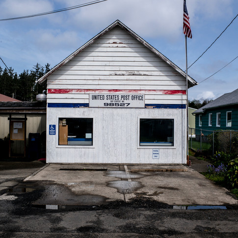
On the way in to Shaniko we diverted ever so slightly to the town of Antelope (pics below), which is just to the south. There’s not much to Antelope from the street, a few signs of life, a post office, but many of the buildings appear abandoned. There was an old building with metal walls and a faded sign that really caught my eye, but the light was not interesting when we were there so we didn’t linger. Besides, it was time to start thinking about a hotel for the night. Given the uncertainty of finding anything to the north or northwest in a reasonable amount of time, we crashed in Madras that night for fear of not being able to find a hotel for a long time and we were getting weary. It was our plan was to forge towards the northwest in the morning.
One of our ground rules as we planned this trip was any time either of us wanted to stop and photograph something, we would. That was, after all, the primary motivation for the trip. Traveling with photographers can be pretty boring as we tend to stop a lot, but with someone that has similar interests, it’s not. To that end, I had this nagging itch to get back to Antelope, even though it was slightly out of the way, and photograph that building and the others in the morning light. While still in the Madras hotel parking lot, Steve pulled out his Butler motorcycle maps which reliably highlight interesting roads, and it turned out the 218 out of Antelope to the east was highly rated as a gorgeous drive. So, rather than aim the car towards the Olympic peninsula, back we went to Antelope even though it and the route to follow were out of our way.

Pun intended.


What makes Antelope interesting, as far as recent American history anyway, is that it’s near the former site of Rajneeshpuram, the story of which can now be seen on the Netflix docu-series called Wild Wild Country. You can read about this history here. In short, in 1981 or so, an Indian spiritual (or cult, depending on who you ask) leader named Bhagwan Shree Rajneeshpurchased the 64,000 acre Muddy Ranch(with its own interesting history) and started a community for his followers, a community which grew to 7,000 with the infrastructure of a small town. The sixty or so residents of Antelope didn’t take kindly to their new neighbors, but were overwhelmed with new voters as and there were bitter disputes about land use, and many other things. Antelope was overwhelmed when Rajneeshee residents purchased enough parcels in the town to outvote the locals. I couldn’t help but think about the irony of recent colonialists so fervently opposing a new group of people, but I digress. After the 1983 bombing of the Hotel Rajneesh in Portland by a militant Islamist group, Rajneeshpuram became visibly militarized, further raising tensions. In 1984, Rajneesh left the country as part of a plea deal for immigration violations, and his followers left soon thereafter. His secretary, Ma Anand Sheela (Sheela Silverman) and a number of other top officials left the commune in 1985. After that, Rajneesh gave a press conference in which he publically accused her and her team of many crimes in and outside of the commune, including wiretapping, poisonings, attempted murder and arson. She was extradited from Germany and jailed. Among other things, Sheela had allegedly had a role in the poisoning of salad bars in nearby Dalles, which reported sickened approximately 750 people with Salmonella, hospitalizing 45.
The rest of the Butler-recommended route that day stunning. Gorgeous streams, mountains, rock formations with a strata I’ve never seen before, old farm houses, small towns, totally out of our way and worth it. We took the 218 to the 19 North the junction of which is in Fossil, Oregon and to the north were Mayville, Condon and more stunning scenery, old buildings and weird along the way. We stopped quite a bit on this leg.
East of Antelope to Fossil & to the North

Looking in the window of an abandoned garage/barn near Fossil, Oregon.


Stonehenge?
We crossed the Columbia River from Oregon into Maryhill, Washington at Biggs Junction. We couldn’t help but wonder what the Stonehenge signs were about, so we followed them. Maryhill Stonehenge purports to be a replica of the original Stonehenge, and was erected by a wealthy entrepreneur named Sam Hill, and dedicated in 1918 to victims of World War 1, though construction wasn’t completed until 1929. The things one stumbles upon. There were a bunch of people up there trying to get gas money for their old busses, and offering to sell crystals, weavings and such. And there were lots of buzzards flying overhead. When the one below looked at me, I told him I wasn't ready.


Whether in Oregon or Washington, the drive along the Columbia River is absolutely stunning.

Olympic Peninsula, Washington
The next real destination was the Olympic Peninsula, including the Hoh Rainforest and Point Flattery, the furthest northwest one can go in the continental United States. I went to the Hoh Rainforest last year, and I could easily spend a long time there. It’s so magical, everything covered in lush green moss, ancient trees, new trees growing out of long dead trees, the birds, and sounds. Some of the sounds are a bit haunting the further in one goes. You hear the sound of wood cracking occasionally, and given all the giant fallen branches and trees one has to navigate, I paid close attention to those sounds.


We then trudged along the western side of the Olympic, checking out some beaches along the way. The plan was to stay in Port Angeles that night so we could catch the early morning ferry over to Victoria, BC. Steve had mentioned how much he wanted to see Cape Flattery, but by the time we would get there, going to Cape Flattery meant making our way to Port Angeles on pitch dark windy roads we didn’t know. We went for it, and it was worth it. It seemed fitting that after walking the trail down to the Cape Flattery viewpoint, I was so awed by how gorgeous it was that I didn’t notice the board missing at the end of the viewpoint and my leg went right through it. I reckon I’m not the only one that’s done that. Happily nothing broke (on me or my gear).


From Port Angeles, we took the ferry over to Victoria, British Columbia, where I was very eager to assuage my savage thirst with the Wilsons, who’d moved there a little over a year ago from Austin, Texas. I wholeheartedly support such radical change, of course. We spent a few days there with our feet up, shared a lot of laughter, stories and a few great meals, and we headed back on the ferry a few days later, to make our way back on the coast. I gave my camera a rest on Victoria and didn’t take a single picture there this time.
On the way back, we drove the north side of the Olympic Peninsula before heading south west to get back to the coast on mostly backroads. One highlight was East Satsop Road, which follows the Satsop river, and then we took the 12 south west towards Montsanto, a logging town, and with a few more diversions, made our way to the 101 and started marching south. Much of the drive was intensely green, with lots of beautiful marshland, forests, and plenty of weird stuff to photograph.


A Few Words About Clearcutting
On this drive, we saw many clear-cut swaths of forest in Washington and Oregon, often behind a thin veneer of trees along the roadways. In some areas, so much forest has been taken that you can actually see it from space on Google Earth. While I understand the livelihood of many people in these parts depends on logging, and humans have a seemingly insatiable need for wood and paper, I’ve got to believe there’s a better way. Clear cutting is so destructive to habitat, animals, plants, soil, rivers and the environment generally. And it’s truly ugly. I've read that 95% of the original primeval forests in the United States have been destroyed, much of which has been in national forests with the willing complicity of Congress and the United States Forest Service. Even planting new forests in their place, which appears to be the case in some spots, won’t replace what was there in the reasonable lifetimes of any of us and for generations afterwards, if ever. I’ll save a longer rant on this for another time since this is a travelogue, but it would be sugar-coating to simply talk about and show you beautiful things along the way, without at least drawing your attention to some of the less pleasant realities along the way.


Bay Center Washington
Bay Center, Washington, is a small coastal fishing town accessible off the 101 by either Dike Road or (if you miss that heading south and think, ‘shit, I really would like to check that out’) you can make a right at Bay Center Road and that will take you to the town. Both roads are worth driving. Gorgeous coastlines, marshes, farmland, intense colors, beached ships, an old mariner cemetery, piles of oyster shells, ocean birds, and so much more in every direction on that small peninsula. Bay Center was not on the schedule, but it was a really beautiful stop and we explored and photographed there for a few hours.


We then headed towards Long Beach, Washington to have a late breakfast/early lunch at a spot in Seaview called Laurie’s Homestead Breakfast that Steve fondly remembered from a previous trip. Cheap and cheerful, ridiculous portions, and classic American breakfasts. It’s closed by 1:00 p.m., but worth a stop if you’re in the area. You might not need another meal that day if you go. Long Beach, incidentally, claims to be the longest beach in the world, and while I’ll agree that it is long, I’m thinking that’s far from true.
Tillamook, Washington
There is more to Tillamook than the cheese factory of the same name, though it's always worth a stop if you like cheese, but also to see the old Tillamook Air Museum. It’s an enormous structure, even from a distance, and is 1072 feet long, 296 feet wide and 192 feet high. The interior is over seven acres. The old hanger B was one of two built there to house blimps in World War II. We lucked out by showing up there on a Sunday as there was no one around, and lucked out even more by having nice cloudy skies as a backdrop. It would have been a five minute stop without the clouds, but with them we were there for quite a while, and I likely got my next album cover shot.

And then I looked behind and saw the abandoned rail yard near the museum and we shot there for nearly an hour.


Oregon Coast
Just past the Heceta Head Lighthouse, in Florence, Oregon, we pulled off the road to photograph a bridge and give Shadow some play time. We found a spot to run the pup, but there was no where at that location with angles of the bridge we liked. Then we explored behind us towards the ocean, and saw this lighthouse which was just starting for the evening. So we waited a while and photographed it as day segued into evening. According to Wikipedia, the Heceta Head Lighthouse was built in 1894, the 56-foot-tall lighthouse shines a beam visible for 21 nautical miles, making it the strongest lighthouse on the Oregon Coast.

The coastline and dunes at Jessie M. Honeyman State Park are sublime and were empty when we were there.


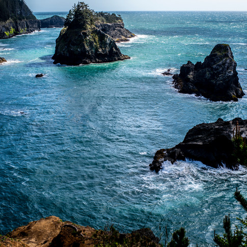
I don’t think one could overstate the beauty of the Oregon coast. People talk a lot about California’s beautiful coast, and it is gorgeous, but further north it’s just breathtaking, more wild, especially throughout the Samuel H. Boardman State Scenic Corridor. Not all of these spots are obvious at all from the interstate, but I encourage anyone heading to those parts simply explore as much as possible.


Humboldt Redwoods State Park
By the time we got to northern California, the only things left on the agenda were visiting a friend of mine in Humboldt for lunch, seeing the redwoods and blasting all the way home in a straight shot, which we did in what was the bookend to our first 750 mile day. Humboldt Redwoods State Park is a treasure. It’s one of the largest contiguous strands of old-growth giant redwoods remaining in the world, and you're likely to see lots of antelopes around there as well.


Photographing the redwoods is challenging, not only because of how large they are, but the dynamic range in any wide angle shot in the forest is extreme from bright sunny skies to the dark forest floor. It requires some averaging along the way, and I do my best to preserve the highlights and details in the darker areas. The video below will offer I think a better or at least different perspective of that forest than I was able to shoot with my still cameras. It's uploaded at 1080p, so if you have the bandwidth, I suggest watching in high resolution.
In Sum
All in, this road trip was 10 days, 3250 miles, 3,481 photographs, a bunch of video, a lot of laughter, a few whiskeys and vodkas, great conversation, discovery, and a massive reservoir of dream fodder of the imagery along the way from which I will draw for years. A superb journey.
Geek Notes:
Cameras: Leica M-P Typ 240 with 28mm and 35mm lenses; Nikon D810 with 16-35, 70-200, and 200-500 mm lenses. For the images above where the file name appears, those with an “L” in the second number of the file names were taken with the Leica and those with “DSC” prior to the second number were taken with the Nikon.
Photos edited in Lightroom
I brought my Mephoto carbon fiber tripod, but I didn’t use it much, other than for photographing the Oregon lighthouse and for that shot I also used a cable release to minimize camera vibration.


Comments